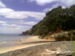
 We took the walkway down to Ladies Bay and walked along the coast to Karaka Bay. This took quite a while, and originally we had intended just to walk back up the Ladies Bay walkway
 and continue along the track in the handy leaflet from Auckland City Council. But we just seemed to keep walking. Once we were out of Ladies Bay itself it was very noticeable that there weren't any other women, although there were a fair few naked men. Oh I tell a lie, there was one woman. She was posing for top-less soft porn shots. I guess that's what happens in a nudist area. I didn't mind the nudity, but I didn't much like the stares from all the men.
There was this weird thing in the water, all encrusted with shellfish, and fantastic views of Browns Island.  I love the shape of Motukorea, it looks as if it were lovingly sculpted by hand. Nickname Pending pointed out that it is quite reminiscent of Mangere Mountain. Perhaps all denuded volcanoes look a bit similar?
Anyway, Karaka Bay was great - quite a surprise. There was no road access and although the houses were obviously valuable it looked like a hippy-ish kind of place. The Treaty of Waitangi was apparently signed there on 4th March 1840 and there is a little rest place with a plaque commemorating it.
At Karaka Bay we followed a path up to the road and then followed the streets around to Anderson Bay, where we took a track that wound behind the houses and right on the cliff edge, looking across the Tamaki to Musick Point and Bucklands Beach.
Then we were back on the road again, skirting Roberta Reserve (Tahuna Torea starts on the other side of it) where we stopped for a snack, before heading up through Glendowie Park. It's a strange place, the ground is very undulating, so it seems kind of useless for playing much. My theory is it used to be landfill and needs to subside more before it can be flattened off, but I really have no idea. We got a little bit lost at the end of Churchill Park but eventually found Glover Park, which is basically the crater of Whakamuhu with playing grounds in the middle. We walked up Waitara Rd and along the edge of the crater, looking back across the park to yet another water tower on the hills above St Heliers.


1 comment:
Great info, thank you. Some of the older Glendowie locals say that Glendowie Park was indeed once a landfill - I think until the fifties.
Post a Comment