Another Rotorua walk (guess where Span went for her holiday!). Again this is not actually in Rotorua, but on a side road off State Highway 5, heading to Taupo. And this is the first walk I've paid for - $28 each for the privilege. This bought us access to the valley, with it's many thermal wonders, and a really quite comprehensive leaflet outlining the key points, local flora and fauna, the route, and with a timetable for the boat (extra, didn't use) and bus (included, used to get back to the start).
Everytime we go to 'vegas and have some spare time we try to go to one of the geothermal areas. Partly this is because I am trying to find the one that I visited when I was about 8, when I stayed for the first time ever in a hotel where they put mints on the pillow at night. Unfortunately Waimangu was not the right smelly part of Rotorua, but it was a good walk.
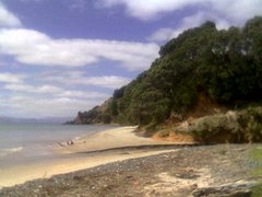
The whole main walk is downhill, starting with some beautiful panoramas from the top. You slowly wend your way down the valley to Lake Rotomahana, where you can pay extra to go on a cruise to where the pink and white terraces used to be.
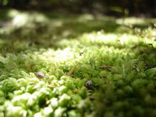
The first geothermal wonder is the Emerald Pool in the Southern Crater, which has some very orderly algae and sphagnum moss. I'm not sure this counts as geothermal as it's cold.
 Next though is the Echo Crater and Frying Pan Lake, as well as the Cathedral Rocks that loom over one end. Seriously large amounts of steam.
 At the end of the lake you can walk right down to a hot water creek and springs, with mineral deposits creating a crazy palette.
 Then there's the brilliant turquoise Inferno Crater and the Bird's Nest Terrace.
 At this point we decided to head up. You can follow the main path along the floor of the valley, following the hot water stream, or you can climb the hiking trail up and over Mt Haszard. I was sure when we bought our tickets that the seller said it was only another 20 minutes, but the leaflet said an extra hour. We did it in about 40 minutes I think.
It is a very rugged track going up, and my there is a lot of up; even the down is very steep. Nice views of the Rift Valley (no, not the one in Africa) and the lake though.
 And also some of these flowers.
 Then it was back to the main track, with more mineral-painted terraces such as the Marble and Warbrick.
  Then a short nature walk to the lake and the bus back up the hill. I was pretty disappointed with the nature walk, until all of a sudden there was a crashing in the bush and a wallaby on the track. A bad time to run out of memory space, luckily it was patient with me.
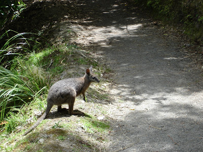 There were two of the blighters, clearly hoping for some food. We callously did not indulge them.
And then we were at the lake.
 All up I think the walk took us around two hours. Unfortunately Nickname Pending didn't check his watch at the start. It's a gentle downhill incline, suitable for wheeled conveniences, with the exception of the Mt Haszard part, as previously mentioned.
 The walk partly follows the river as it heads towards the falls, but wends away at times. Much of the bush has regenerated since the 1886 explosion of Tarawera, and there are massive rocks strewn through the surrounds - often with trees now growing around or through them. It gives you a sense of the power of the eruption to see these huge boulders thrown so far from the mountain. In places the ground is totally overgrown with odd little plants and mosses, in others ferns predominate. The bush here was not like in the Greater Auckland area - few kauri, no nikaus, mostly pohutukawa, rata, and other trees I wasn't familiar with. While we heard a lot of birdsong none came close enough to see or snap.
 and also a very inviting water hole, complete with several rope swings. Very tranquil and restful.
 Ultimately we ended up at Tarawera Falls, where the river spurts out of the cliffs. There's a cobbled area there with a few benches and we stopped to have a picnic before heading back.
  It took us about an hour and a half to get to the falls, stopping a lot for photos. On the way back it started to rain a little so we pushed the pace a bit and made it the whole way back in only an hour. The signs (and leaflet) say two hours each way, and there is quite a bit of up (some with stairs) but mostly it's a gentle slope down on the way to the falls, and obviously the reverse on the way back. I would also advise wearing closed shoes. The track is maintained through small stones which are really annoying if you are wearing sandals, even decent ones like Tevas.
 cattle
 (including one that wanted me to go away) ,
 and lots of nice (largely exotic) trees and long grass.

 We made it most of the way around in plenty of time, so decided to go up to the summit once we hit the west entrance road, as recommended in the book. We basically just followed the road up, along with many others, some of whom were disturbingly running and/or pushing baby buggies. Here's a pic of the summit, while walking up to it:
 And here's the obligatory child-running-around-the-plaque shot,
 Followed by the now mandatory tree's-eye-view(if-there-were-a-tree) pic


 The Tramline Society's mini train - stopped at Picnic Flats when we came across it.


 The West Tunnel track was pretty muddy in parts, and at one point, where we had to cross a stream, it was very difficult to work out where the track went next. There's evidence that the ARC is starting to put boardwalks through, but the work is only just begun and at the moment the track is quite a challenge in parts.
 Looking east from the top:
 Once you reach the top you can either walk back the way you came or take the tramping track down, which is largely unformed and would be very difficult in wet weather. We both had decent walking shoes so we headed down the tougher section, and the grips on my Tevas were indispensable.
 However the noise from State Highway One is pretty full on from about half-way down the hill until the track stops following the road and turns back into the park around half an hour later. At one point there was a whole gaggle of loud motorbikes heading across the Waiwera bridge, and even though we were a considerable distance away the noise reverberated around the bush and disturbed the peace.
 Almost the entire walk is through bush cover, until you start walking back to the carparks, along the road into the park itself. Here there are cows and sheep, not to mention a really large number of ducks. Before heading back to the car, after about an hour and a quarter of walking, we decided to have a quick squizz at Couldrey House.
 Lovely spot, unfortunately it was $2 each to go in, which is fine except when you don't have any cash on you.
 Great set-up, interesting walk with information points along the way, definitely keen to come back and do some of the other tracks in the area, particularly the Puhoi walk which includes the pa area itself.
 On top of Mt Victoria is a weather station, and a field of airvents decorated as mushrooms. The weather station reminds me vaguely of the Empire's probe on Hoth.

 We then headed down Mt Victoria, following the road, then headed up Kerr Rd, along St Aubyn's, left down Church, and into the Mt Cambria Reserve. Most of the time we walked between Mt Victoria and North Head we seemed to be on the Walking School Bus route for Devonport School:
 Mt Cambria isn't really a mountain, or even a hill. Maybe it was quarried away, there's certainly a lot of stone used in walls around the area. Whatever, it's really just a slight rise, topped by this lookout.
 The reserve itself includes the Devonport Museum (which was closed) and the walks within it are well laid out although neglected.