Today we went on a lighter walk, with the aim of assaulting the previously attempted Mangere Mountain (rained out). We parked at The Landing, on Onehunga Mall, and headed off across the Old Mangere Bridge, now closed to cars but open to fishers.
 The wind was blowing something fierce, as we walked past the concrete works, across the old bridge and into the pleasant suburb of Mangere Bridge. We headed through the strip shops on Coronation Rd, then up MacIntyre Rd, followed by Scott Rd, which led to the carpark at the base of the summit to Mangere Mountain.
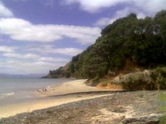
 We walked around the crater rim, gradually heading up and up and up. Great views out across the Manukau Harbour, which of course includes the former sewerage ponds.

 We could also see a number of other Greater Auckland peaks including One Tree Hill,
 and Rangitoto (with the cement works and bridges in the foreground).
  All of the plaques had been vandalised, but one showed the volcanic processes that had formed the mountain. We didn't notice until too late to read about this through the tags, but there is a little hill in the middle of the main crater, the perfect place for a wicked game of Spotlight.
 There were quite a lot of people on the mountain, mostly just walking, sometimes with dogs, but also flying remote control gliders. Mangere Mountain has two peaks, both with navigation thingbos. Here's the lower of the two, from most of the way up.
 Once we'd walked right around the rim we headed back down Hastie Ave, cut through Mangere Bridge School to do the fitness trail (the monkey bar defeated me), then back along Coronation Rd to the Gasoline Alley station.
From that point we diverged from our path to the mountain, heading instead for the walkway under the New Mangere Bridge, which started on the other side of a park. It was covered in graffiti, which actually looked really beautiful as it was so multi-coloured. Not quite the Via Dell'amore in Cinque Terre, but still fab.
 Half way across there was a lookout, and in the water below a trolley cemetry.
 Took an hour and three quarters, I stopped alot for pics (as always). An easy walk, but the tracks on the mountain are not properly formed, only goat trails, and as a result there are some parts where the footing is poor, particularly near the top of the mountain where there is a high amount of scoria. A good walk for a good weather day.


No comments:
Post a Comment