Mt Richmond is next to Sturges Park, and you can access a road to the base of the hill from either Great South Rd or Mt Wellington Highway. It's quite neglected, although the potholes have (mercifully) recently been filled.
We parked and walked up along the crater rim, which is quite extensive. There are some massive and majestic trees, including camera-defying Moreton Bay figs (which may be familiar to some readers from Albert Park, while Monte Cecilia Park has some of the largest examples in NZ.)  We could see the geometric marker, but it took us quite a while to work out how to get there, as the trees are big, and thus mask much of the park.
We could see the geometric marker, but it took us quite a while to work out how to get there, as the trees are big, and thus mask much of the park. 
Whilst trying to reach it we found a really enormous fungus growing on a felled tree,
 and stumbled across some very flighty goats and a single sheep. They insisted on either standing in the shade or running away (or both) so no snaps of them. There were cows too, but after my experience in Cornwall Park I wasn't game to get up close enough for a decent pic.
Eventually we figured out how to get up to the marker, along the way spotting previously conquered Mangere Mountain, amongst other volcano peaks.
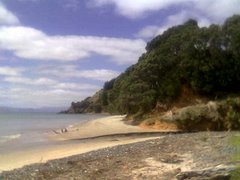
 At the top we could see the Otahuhu Power Station too (the two tall grey chimneys right in the centre of the photo).
 We also discovered there was a water tower (a la The Big King) on one of the other summity bits.
Then we tottered down, and drove back to Great South Rd, to the entrance to Mutukaroa-Hamblin's Hill Regional Park.
We initially went in via a sub-optimal route, but it worked out. There is a carpark and entrance on Great South Rd, not far from the intersection with Sylvia Park Rd. The park is a working farm also, so there is a loading yard at the entrance.
 Of all the ARC Parks we have visited so far this is the least visitor-friendly. It's clear that they have only been developing the non-farm aspects such as walks and native plantings since about 1998 or 1999, and there is little sign-posting of where to go from the entrance. We walked through some planting done in a previous quarry,
  and tried to get up to the peak of Hamblin's Hill (another water tower) but it wasn't obvious where to go, so we figured maybe you weren't meant to head up there just yet.
 Instead we took a walk down hill through reasonably new bush to the South Eastern Motorway. Again the lack of development was obvious, and at one point there was a signpost that took us off to a dead end. There was also a clearing at one point with a rusty water tank, an area fenced off for no apparent reason and a park bench.
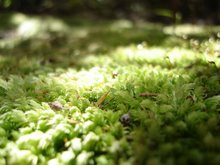
 The shed at the start of the walk says there are tobacco plants throughout the bush, but sadly I don't know what they look like. It was a lovely walk through the bush, despite the lack of finishing, with some plants I certainly hadn't seen anywhere else.
Mt Richmond took us about 45 minutes, and we rambled around quite a lot. I would recommend closed shoes and long trousers (in hindsight) due to a lot of long grass and nasty things underfoot. Hamblin's Hill took up roughly 55 minutes, but hopefully in the future there will be more walks available, in particular to the summit.


1 comment:
Thank you for the lovely photo's of Mt Richmond. Some time ago, a sheep escaped slaughter at The old Westfield abatoir, and ran into Mt Richmond to take up residence with a herd of cows. He became their "leader" and lived happily with them. When he was removed for shearing, the sheep became so depressed that he had to be returned urgently to join the cows.
Please could you tell me, or find out, if he is still there and what became of him. ? ?
Many Thanks
Post a Comment