Last weekend was consumed by the Great Cat Crisis of 2007, while this one has revolved around the much nicer event of a wedding.
Hopefully back on the tracks next Saturday.
Saturday, February 24, 2007

Wednesday, February 14, 2007
River and waterfall walks, Maungaroa Station - 11th Feb. 2007
Step 1. Drive to Te Kaha on the East Coast, on SH35.


 And what farm-based walk post would be complete without a donkey shot?

Step 2. Turn right (if coming from Opotiki, left if coming from Gisborne) up Copenhagen Rd.
Step 3. Drive along it until you come to the unsealed road marked with a sign marked Maungaroa Station Rd.
Step 4. Gently proceed along said road, trying to avoid the really big stones unless you dislike the underside of your car and want to punish it for unspeakable transgressions.
Step 5. Continue through a gate marked Maungaroa Station, being careful of course to shut it after you if it is open.
Step 6. Keep driving for a considerable distance more along an ever worsening road, including across dry riverbeds, until you reach some houses. At that point you may wish to approach the one with the cute puppy and ask for a) permission and b) directions to the walk.
We headed up river for about an hour and a half then walked back. This involved a lot of crossing the river back and forth, picking the shallowest spots. For this reason shorts and sandals are the go.
On the way back we took a short track to a small waterfall, marked by neon spraypaint on trees.
All up, including a stop for lunch and several shorter breaks to attempt to skim stones, take pics, avoid scaring cows, over 3 and a half hours (plus the drive there and back).
And here are some pics:
And what farm-based walk post would be complete without a donkey shot?Friday, February 02, 2007
Three tracks, Duder's Regional Park - 3rd Feb. 2007
Today Nickname Pending and I drove out eastwards to Duder's Regional Park, and this time it wasn't raining.
The park sits on a peninsula, with a historic pa site on the far end, and a whole lot of farm between the carpark (with helpful signs and map leaflets) and that headland.
We started out by heading left from the carpark, following the red markers of the Farm Loop. This involved some pretty unpleasant up within a few minutes, and it actually hurt to breathe. The views from the top of the ridge were great - the farmland to the south and south-west, the Hauraki Gulf to the north, tidal flats and wetlands to the east, and Duders Bay sweeping to the west. We continued to follow the red markers through various fields on the ridge, some dotted with skittish ovines and one including the trig station.
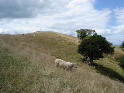 Eventually we came to a post that also had blue markers, which indicated the Whakakaiwhara Pa Walk. Sadly at this point we went the wrong way and ended up not heading towards the end of the peninsula, but at the start of a coastal walk.
We decided to follow this for a while and see where it went. When the coastal walk petered out we kept going around the coast (luckily the tide was out) and eventually found a spot to clamber up and rejoin the Whakakaiwhara Pa Walk, almost at the headland itself.
 There at the end of the peninsula, where once there were defensive trenches and kumara pits, was a lovely restful spot where you could gaze out at the Gulf, Waiheke Island, Ponui, Pakatoa and even Rangitoto in view.
And then, the best thing happened - what appeared to be a fishing boat turned out to be a full size waka, clearly on it's way to Okahu Bay for Waitangi Day on Tuesday. Fantastic to watch it at full steam, and we walked much of the way back along the ridge to rejoin the Farm Loop with their coordinating chants ringing in our ears.
 Then we went through the cow paddock

The park sits on a peninsula, with a historic pa site on the far end, and a whole lot of farm between the carpark (with helpful signs and map leaflets) and that headland.
We started out by heading left from the carpark, following the red markers of the Farm Loop. This involved some pretty unpleasant up within a few minutes, and it actually hurt to breathe. The views from the top of the ridge were great - the farmland to the south and south-west, the Hauraki Gulf to the north, tidal flats and wetlands to the east, and Duders Bay sweeping to the west.
We continued to follow the red markers through various fields on the ridge, some dotted with skittish ovines and one including the trig station.Eventually we came to a post that also had blue markers, which indicated the Whakakaiwhara Pa Walk. Sadly at this point we went the wrong way and ended up not heading towards the end of the peninsula, but at the start of a coastal walk.We decided to follow this for a while and see where it went. When the coastal walk petered out we kept going around the coast (luckily the tide was out) and eventually found a spot to clamber up and rejoin the Whakakaiwhara Pa Walk, almost at the headland itself.
There at the end of the peninsula, where once there were defensive trenches and kumara pits, was a lovely restful spot where you could gaze out at the Gulf, Waiheke Island, Ponui, Pakatoa and even Rangitoto in view.And then, the best thing happened - what appeared to be a fishing boat turned out to be a full size waka, clearly on it's way to Okahu Bay for Waitangi Day on Tuesday. Fantastic to watch it at full steam, and we walked much of the way back along the ridge to rejoin the Farm Loop with their coordinating chants ringing in our ears.
Then we went through the cow paddock and along part of the Farm Loop again, and followed the metal road back to the carpark. Which had another one of those previously controversial frames (just like at Cascades).
All up it took us 2 hours 45 minutes, despite the error, and with the now customary many photo stops. Good walking shoes are essential, and there is a lot of long grass. Also for the first time since walking at John O'Groats in Scotland in May I felt the need of insect repellent.
Wonderful, varied, views - a good place to take visitors to NZ if they are ok with uneven land and massive bovines.
(Pics added 8.45pm Sunday 4th Feb 2007)
Wonderful, varied, views - a good place to take visitors to NZ if they are ok with uneven land and massive bovines.
(Pics added 8.45pm Sunday 4th Feb 2007)
Waiheke Sculpture Walk - 1st Feb. 2007
Attentive readers may have noticed that the above date is a work day. This was indeed a work trip, and the photos have been stolen from a colleague and are thus not my own product.


Caught the ferry from the CBD, which then went through Devonport and then landed at Matiatia. From there we caught a shuttle up to the start of the Sculpture walk itself, but I'm sure you could walk it.
The walk is free and the brochures that explain the artworks are $5. There is a little station at the start that you can purchase brochures and water from, and half way around there's a delightful coffee stall, which also had hot chocolate but not trim milk.
The walk itself is actually part of the track to Church Bay, winding around the edge of the peninsula that is to the right as you enter Matiatia on the ferry. Lovely views and a well constructed track in most parts (although I understand there are some local politics around land-owners encroaching on public walkways through out the island).
The sculptures were modern, and mostly very clever. I particularly liked Clip Clop, which is a bridge with lose planks that create a xylophone effect. The blurb in the brochure talks about the story of Billy Goat Gruff and there is an obviously political element to the piece, in terms of local land ownership and use issues.
There's also a great fun work with orange and pink hats and scarves which you can use and return to a wooden box later on the walk.
Here are some of the pics of the sculptures, which are arrayed along the cliff edges, taken by my colleague:
All up I think it took us maybe an hour, but I don't have a watch. I didn't even have to wear decent walking shoes - just slides - and at time I went barefoot as it was nice grass.
Saturday, January 27, 2007
Mt Richmond & Hamblin's Hill - 27th Jan. 2007
Yesterday we ventured to the southern most reaches of Auckland City, first to Mt Richmond in Otahuhu and then to Mutukaroa-Hamblin's Hill in Sylvia Park.

 and stumbled across some very flighty goats and a single sheep. They insisted on either standing in the shade or running away (or both) so no snaps of them. There were cows too, but after my experience in Cornwall Park I wasn't game to get up close enough for a decent pic.
Eventually we figured out how to get up to the marker, along the way spotting previously conquered Mangere Mountain, amongst other volcano peaks.
 At the top we could see the Otahuhu Power Station too (the two tall grey chimneys right in the centre of the photo).
 We also discovered there was a water tower (a la The Big King) on one of the other summity bits.

 Of all the ARC Parks we have visited so far this is the least visitor-friendly. It's clear that they have only been developing the non-farm aspects such as walks and native plantings since about 1998 or 1999, and there is little sign-posting of where to go from the entrance. We walked through some planting done in a previous quarry,
 and tried to get up to the peak of Hamblin's Hill (another water tower) but it wasn't obvious where to go, so we figured maybe you weren't meant to head up there just yet.
 Instead we took a walk down hill through reasonably new bush to the South Eastern Motorway. Again the lack of development was obvious, and at one point there was a signpost that took us off to a dead end. There was also a clearing at one point with a rusty water tank, an area fenced off for no apparent reason and a park bench.
 The shed at the start of the walk says there are tobacco plants throughout the bush, but sadly I don't know what they look like. It was a lovely walk through the bush, despite the lack of finishing, with some plants I certainly hadn't seen anywhere else.
Mt Richmond is next to Sturges Park, and you can access a road to the base of the hill from either Great South Rd or Mt Wellington Highway. It's quite neglected, although the potholes have (mercifully) recently been filled.
We parked and walked up along the crater rim, which is quite extensive. There are some massive and majestic trees, including camera-defying Moreton Bay figs (which may be familiar to some readers from Albert Park, while Monte Cecilia Park has some of the largest examples in NZ.)  We could see the geometric marker, but it took us quite a while to work out how to get there, as the trees are big, and thus mask much of the park.
We could see the geometric marker, but it took us quite a while to work out how to get there, as the trees are big, and thus mask much of the park. Whilst trying to reach it we found a really enormous fungus growing on a felled tree,
and stumbled across some very flighty goats and a single sheep. They insisted on either standing in the shade or running away (or both) so no snaps of them. There were cows too, but after my experience in Cornwall Park I wasn't game to get up close enough for a decent pic.Eventually we figured out how to get up to the marker, along the way spotting previously conquered Mangere Mountain, amongst other volcano peaks.
At the top we could see the Otahuhu Power Station too (the two tall grey chimneys right in the centre of the photo). We also discovered there was a water tower (a la The Big King) on one of the other summity bits.Then we tottered down, and drove back to Great South Rd, to the entrance to Mutukaroa-Hamblin's Hill Regional Park.
We initially went in via a sub-optimal route, but it worked out. There is a carpark and entrance on Great South Rd, not far from the intersection with Sylvia Park Rd. The park is a working farm also, so there is a loading yard at the entrance.
Of all the ARC Parks we have visited so far this is the least visitor-friendly. It's clear that they have only been developing the non-farm aspects such as walks and native plantings since about 1998 or 1999, and there is little sign-posting of where to go from the entrance. We walked through some planting done in a previous quarry, and tried to get up to the peak of Hamblin's Hill (another water tower) but it wasn't obvious where to go, so we figured maybe you weren't meant to head up there just yet.Instead we took a walk down hill through reasonably new bush to the South Eastern Motorway. Again the lack of development was obvious, and at one point there was a signpost that took us off to a dead end. There was also a clearing at one point with a rusty water tank, an area fenced off for no apparent reason and a park bench. The shed at the start of the walk says there are tobacco plants throughout the bush, but sadly I don't know what they look like. It was a lovely walk through the bush, despite the lack of finishing, with some plants I certainly hadn't seen anywhere else.Mt Richmond took us about 45 minutes, and we rambled around quite a lot. I would recommend closed shoes and long trousers (in hindsight) due to a lot of long grass and nasty things underfoot. Hamblin's Hill took up roughly 55 minutes, but hopefully in the future there will be more walks available, in particular to the summit.
Saturday, January 20, 2007
Mangere Bridges and Mountain - 21st Jan. 2007
Today we went on a lighter walk, with the aim of assaulting the previously attempted Mangere Mountain (rained out). We parked at The Landing, on Onehunga Mall, and headed off across the Old Mangere Bridge, now closed to cars but open to fishers.
 The wind was blowing something fierce, as we walked past the concrete works, across the old bridge and into the pleasant suburb of Mangere Bridge. We headed through the strip shops on Coronation Rd, then up MacIntyre Rd, followed by Scott Rd, which led to the carpark at the base of the summit to Mangere Mountain.
 We walked around the crater rim, gradually heading up and up and up. Great views out across the Manukau Harbour, which of course includes the former sewerage ponds.

 We could also see a number of other Greater Auckland peaks including One Tree Hill,
 and Rangitoto (with the cement works and bridges in the foreground).
  All of the plaques had been vandalised, but one showed the volcanic processes that had formed the mountain. We didn't notice until too late to read about this through the tags, but there is a little hill in the middle of the main crater, the perfect place for a wicked game of Spotlight.
 There were quite a lot of people on the mountain, mostly just walking, sometimes with dogs, but also flying remote control gliders. Mangere Mountain has two peaks, both with navigation thingbos. Here's the lower of the two, from most of the way up.
 Once we'd walked right around the rim we headed back down Hastie Ave, cut through Mangere Bridge School to do the fitness trail (the monkey bar defeated me), then back along Coronation Rd to the Gasoline Alley station.
From that point we diverged from our path to the mountain, heading instead for the walkway under the New Mangere Bridge, which started on the other side of a park. It was covered in graffiti, which actually looked really beautiful as it was so multi-coloured. Not quite the Via Dell'amore in Cinque Terre, but still fab.
 Half way across there was a lookout, and in the water below a trolley cemetry.
 Took an hour and three quarters, I stopped alot for pics (as always). An easy walk, but the tracks on the mountain are not properly formed, only goat trails, and as a result there are some parts where the footing is poor, particularly near the top of the mountain where there is a high amount of scoria. A good walk for a good weather day.
Sunday, January 14, 2007
Again no walking this weekend
Saturday was a horrible day, although we drove out to the walk of Nickname Pending's choice in the hope the weather was better out there. It wasn't.
Sunday was taken up with other commitments but turned into a wonderful day.
Next weekend we are going to try to walk on Sunday afternoon, due to other stuff on Saturday.
Sunday was taken up with other commitments but turned into a wonderful day.
Next weekend we are going to try to walk on Sunday afternoon, due to other stuff on Saturday.
Subscribe to:
Posts (Atom)