Mt Richmond is next to Sturges Park, and you can access a road to the base of the hill from either Great South Rd or Mt Wellington Highway. It's quite neglected, although the potholes have (mercifully) recently been filled.
We parked and walked up along the crater rim, which is quite extensive. There are some massive and majestic trees, including camera-defying Moreton Bay figs (which may be familiar to some readers from Albert Park, while Monte Cecilia Park has some of the largest examples in NZ.)  We could see the geometric marker, but it took us quite a while to work out how to get there, as the trees are big, and thus mask much of the park.
Whilst trying to reach it we found a really enormous fungus growing on a felled tree,
 and stumbled across some very flighty goats and a single sheep. They insisted on either standing in the shade or running away (or both) so no snaps of them. There were cows too, but after my experience in Cornwall Park I wasn't game to get up close enough for a decent pic.
Eventually we figured out how to get up to the marker, along the way spotting previously conquered Mangere Mountain, amongst other volcano peaks.
 At the top we could see the Otahuhu Power Station too (the two tall grey chimneys right in the centre of the photo).
 We also discovered there was a water tower (a la The Big King) on one of the other summity bits.

Then we tottered down, and drove back to Great South Rd, to the entrance to Mutukaroa-Hamblin's Hill Regional Park.
We initially went in via a sub-optimal route, but it worked out. There is a carpark and entrance on Great South Rd, not far from the intersection with Sylvia Park Rd. The park is a working farm also, so there is a loading yard at the entrance.
 Of all the ARC Parks we have visited so far this is the least visitor-friendly. It's clear that they have only been developing the non-farm aspects such as walks and native plantings since about 1998 or 1999, and there is little sign-posting of where to go from the entrance. We walked through some planting done in a previous quarry,
 and tried to get up to the peak of Hamblin's Hill (another water tower) but it wasn't obvious where to go, so we figured maybe you weren't meant to head up there just yet.
 Instead we took a walk down hill through reasonably new bush to the South Eastern Motorway. Again the lack of development was obvious, and at one point there was a signpost that took us off to a dead end. There was also a clearing at one point with a rusty water tank, an area fenced off for no apparent reason and a park bench.
 The shed at the start of the walk says there are tobacco plants throughout the bush, but sadly I don't know what they look like. It was a lovely walk through the bush, despite the lack of finishing, with some plants I certainly hadn't seen anywhere else.
Mt Richmond took us about 45 minutes, and we rambled around quite a lot. I would recommend closed shoes and long trousers (in hindsight) due to a lot of long grass and nasty things underfoot. Hamblin's Hill took up roughly 55 minutes, but hopefully in the future there will be more walks available, in particular to the summit.

 The wind was blowing something fierce, as we walked past the concrete works, across the old bridge and into the pleasant suburb of Mangere Bridge. We headed through the strip shops on Coronation Rd, then up MacIntyre Rd, followed by Scott Rd, which led to the carpark at the base of the summit to Mangere Mountain.

 We could also see a number of other Greater Auckland peaks including One Tree Hill,
 and Rangitoto (with the cement works and bridges in the foreground).
 All of the plaques had been vandalised, but one showed the volcanic processes that had formed the mountain. We didn't notice until too late to read about this through the tags, but there is a little hill in the middle of the main crater, the perfect place for a wicked game of Spotlight.
 There were quite a lot of people on the mountain, mostly just walking, sometimes with dogs, but also flying remote control gliders. Mangere Mountain has two peaks, both with navigation thingbos. Here's the lower of the two, from most of the way up.
 Once we'd walked right around the rim we headed back down Hastie Ave, cut through Mangere Bridge School to do the fitness trail (the monkey bar defeated me), then back along Coronation Rd to the Gasoline Alley station.
 Half way across there was a lookout, and in the water below a trolley cemetry.
 Took an hour and three quarters, I stopped alot for pics (as always). An easy walk, but the tracks on the mountain are not properly formed, only goat trails, and as a result there are some parts where the footing is poor, particularly near the top of the mountain where there is a high amount of scoria. A good walk for a good weather day.
 Cliffs between Narrowneck and Takapuna
 Cormorant with 470 fleet in background.
 Some mysterious rusting metal between Narrowneck and Takapuna
 Typical shell and stone litter between the rocks.


 Next though is the Echo Crater and Frying Pan Lake, as well as the Cathedral Rocks that loom over one end. Seriously large amounts of steam.

 At the end of the lake you can walk right down to a hot water creek and springs, with mineral deposits creating a crazy palette.

 Then there's the brilliant turquoise Inferno Crater and the Bird's Nest Terrace.

 At this point we decided to head up. You can follow the main path along the floor of the valley, following the hot water stream, or you can climb the hiking trail up and over Mt Haszard. I was sure when we bought our tickets that the seller said it was only another 20 minutes, but the leaflet said an extra hour. We did it in about 40 minutes I think.
 And also some of these flowers.
 Then it was back to the main track, with more mineral-painted terraces such as the Marble and Warbrick.
 Then a short nature walk to the lake and the bus back up the hill. I was pretty disappointed with the nature walk, until all of a sudden there was a crashing in the bush and a wallaby on the track. A bad time to run out of memory space, luckily it was patient with me.
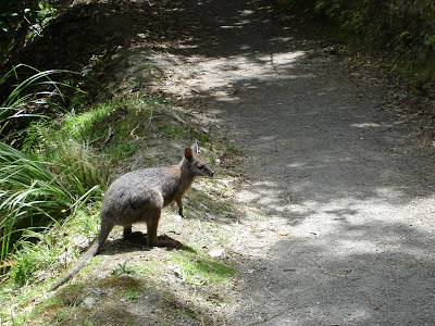 There were two of the blighters, clearly hoping for some food. We callously did not indulge them.
 All up I think the walk took us around two hours. Unfortunately Nickname Pending didn't check his watch at the start. It's a gentle downhill incline, suitable for wheeled conveniences, with the exception of the Mt Haszard part, as previously mentioned.
 The walk partly follows the river as it heads towards the falls, but wends away at times. Much of the bush has regenerated since the 1886 explosion of Tarawera, and there are massive rocks strewn through the surrounds - often with trees now growing around or through them. It gives you a sense of the power of the eruption to see these huge boulders thrown so far from the mountain. In places the ground is totally overgrown with odd little plants and mosses, in others ferns predominate. The bush here was not like in the Greater Auckland area - few kauri, no nikaus, mostly pohutukawa, rata, and other trees I wasn't familiar with. While we heard a lot of birdsong none came close enough to see or snap.

 and also a very inviting water hole, complete with several rope swings. Very tranquil and restful.

 Ultimately we ended up at Tarawera Falls, where the river spurts out of the cliffs. There's a cobbled area there with a few benches and we stopped to have a picnic before heading back.
 It took us about an hour and a half to get to the falls, stopping a lot for photos. On the way back it started to rain a little so we pushed the pace a bit and made it the whole way back in only an hour. The signs (and leaflet) say two hours each way, and there is quite a bit of up (some with stairs) but mostly it's a gentle slope down on the way to the falls, and obviously the reverse on the way back. I would also advise wearing closed shoes. The track is maintained through small stones which are really annoying if you are wearing sandals, even decent ones like Tevas.